| Back to Cowling page | Earl Crags and Lund Tower from Cowling in West Yorkshire |
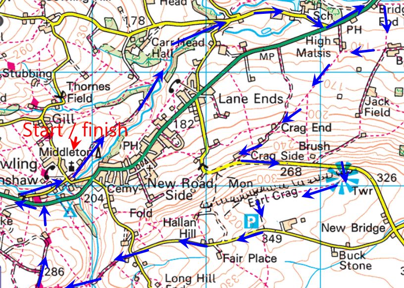
This 6 and a half mile walk starts at the Parish church of Ickonshaw at Gill Lane Cowling. Parking is available here. After parking, take the farm track to the right of the church and follow this as it becomes a green path. The path is obvious and you cant go wrong,
The path is eventually met by a flagged path from the right, bear left and follow this then turn sharp left over a large green framed footbridge crossing Gill Beck over the bridge Turn right and follow the river bank. In the field on the left you’ll see what looks like a lime Kiln, I don’t think it is, as this isn’t a limestone area. Follow the riverbank to reach another footbridge on the right, back over the river to emerge on a road. Turn left and walk uphill to meet a junction. Turn right here and follow this road to the main A6068 Colne to Keighley Road.
Turn left and follow the tree line footpath. Pass the Dog and Gun and has you reach the bridge over the river, cross the road and pass through a small metal gate. A short path brings you to a stone wall and junction of paths. Turn sharp right and follow this path with the stone wall on your left. This was very wet when I walked it and I had to climb over the wall into the field to bypass a flooded section. The path soon meets a concrete farm track. Carry on and look for a small wooden stile on the right. This is the official footpath that follows the track but in the field behind the hedge.
Follow hedge to top corner and through a gap stile back on to the farm track but now beyond the farm. Carry on up to reach a gate. Straight on and into a narrow field, that narrow its more like a wide green lane. This rises upwards and just passed a small barn on the right it steepens. Climb on to reach a gate that leads on to another farm track just to the right of a row of stone houses (might be one big house) Turn right up the concrete farm track, climbing all the way to reach the road with Earl Crags right in front of you.
Turn left along the road, still going uphill, you can see Lund Tower on your right and you’ll soon reach a signed footpath on the right leading up on to the crag. Climb a few steps to the path at the top. A short walk to the left takes you to the tower, A narrow spiral staircase inside takes you to the top for a superb view.
Trace your steps back and follow the superb path along the top of Earls Crag heading for Wainmanns pinnacle, another stone monument. Pendle hill rises majestically in the distance behind the Pinnacle.
Having explored the superb crags, and at the Pinnacle turn sharp left to follow the wall on your left, to emerge at a small car park. Turn right and follow this road as it gently descends. As the lane bends sharply to the right, continue straight on, down a farm track, shortly reaching a ramshackle occupied house on the left, the track turns right and again descends into a lovely valley. A the bottom the remains of a bridge crossing the beck are now just two concrete blocks. No matter, we pass this to ford the stream with a gate heading up the other side.
Through this gate and another steep climb begins. Follow this track uphill to meet a farm track. Turn right and head on slightly uphill to where the main track goes left at a farm. Continue straight on here down a grassy track through two mettle gates. Continue onwards now dropping again on a rough grass path to the next farm house. Keep to it’s right, through two gate stiles, across the farm track to another gate stile into field, Signposted The Pennine Way. The path goes slightly left across the field, you are now on the Pennine Way. The field path drops down towards the main road. Cross the road and turn left, White painted PW arrows and markers leave you in no doubt.
After just a few yards, just before the Black Bull, turn right over a stile again signposted PW, to drop down to the road at Ickonshaw. Turn right and walk through the village back to the Parish Church where you started.